

Check out Mt. Anthony trails on Trailforks
Check out our new trail, Zaphod’s Run!
Trail Conditions
Know before you go. We will update alerts on Facebook ‘Bennington Area Trail System- BATS first and the BATS homepage if we have time. Use trails at your own risk.
Report any less than ideal trail conditions to us at [email protected] or message us on Facebook.
See Trail Rules & Guideline Page for more important information.
Please Note:
-The trail to the summit is not maintained (no view, and owned by the Utility company).
-Many of the older logging roads and trails are not maintained by BATS. Some of the trail names that were on this old system, and in use by BATS, and some are not.
-There is a network of mowed paths that were maintained by Southern Vermont College. The trails are currently being maintained by SVMC.
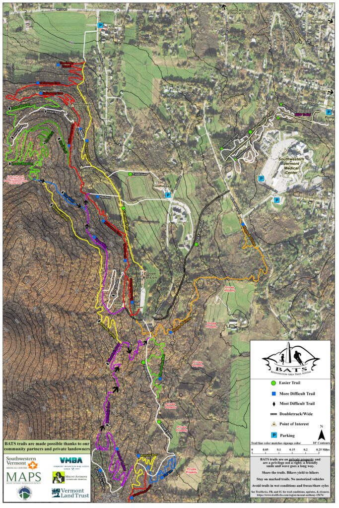
TRAIL DIFFICULTY RATINGS
Trails are rated in difficulty similar to ski trails. The rating is on our map. The rating color is different than the trail blazes (plastic diamonds on trees/posts).
Green Circle= gentler grade, more beginner trail
Blue Square= intermediate, more hills, possibly more technical
Black Diamond= difficult, hillier, more technical
TRAIL DESCRIPTIONS
Carriage Road – 0.4 mi. (Beginner, Yellow Blazes): Is a Beginner friendly trail which takes you along the old access road to the Everett Mansion. An old stone cobble road leads to an overlook with excellent views of the Vermont Valley, Battle Monument, and Green Mountains.
Cave Trail – 0.6 mi. (Intermediate, Yellow Blazes): Connects the Carriage Road with the the Garlic Fest parking/field at Camelot Village. The Everett cave can be found just upslope from the southern portion of the trail.
Everett Path – 0.3 mi. (Intermediate, Red Blazes): Starts at the south end of the Everett Mansion parking lot by the kiosk, and runs along the gravel road to the water tank. It then runs above the mansion cascades descending down to the Carriage Road.
Fieldhouse Trail (Beginner, Orange Blazes): a mowed path that connects the SVC fieldhouse to the Carriage Road. If on a bike please use these narrower mowed paths, not the wide SVC XC team paths
Fillmore Forest- (Intermediate- Red Blazes): An extension of Halloween Tree and a fun connector up from the Garlic Fest Field/Vermont Land Trust easement. Connects to the Cave Trail or continue up Halloween Tree.
Halloween Tree – 2 mi. (Intermediate, Red Blazes): Draws its name from an old growth burled sugar maple tree alongside the trail. The trail runs from the Carriage Road north of the Everett Mansion along the Northeastern flank of Mount Anthony, ending at the Garlic Festival field at Route 9 and Fox Hill Road. The trail was built in the Spring and Summer of 2016 and can be ridden in both directions.
Hops and Vines – 1.2 mi. (Intermediate, Orange Blazes): was the first new trail that BATS built in the Fall of 2015. It was built with mountain biking in mind, but makes an excellent running, hiking, and xc skiing trail. It can be ridden both ways and runs from just south of the Everett Mansion down to Monument Ave by the Southwestern Vermont Medical Center.
Lower Beacon – 1.75 mi. (Difficult, Green Blazes): Under Construction with landowner permission. Come to a volunteer work day. This singletrack winds along the contours and connects to Halloween Tree twice, or takes you up to the Lower Beacon where it connects to The Wall.
Snail Trail– A spur off the upper part of Lower Beacon
Old Farm Road – 0.5 (Beginner, not blazed): Can be used to climb back up to the Everett Mansion area from Monument Ave.
Orchard – 0.5 mi (Beginner, Orange Blazes): a mowed path wrapping around the field edge from Old Farm Road connecting to the Northern side of the Fieldhouse. If on a bike please use these narrower mowed paths, not the wide SVC XC team paths.
The Wall (Expert, Blue Blazes): Climbs sharply from the field above the Carriage road. Although a fine hiking trail, it is recommended as a descent on a bike.
Ursa Way – 0.6 mi. (Intermediate, Purple Blazes): climbs a steep pitch above the water tower, and follows an old logging road, eventually descending down to an open field with expansive views of Bennington and the Green Mountains. It is best biked South to North. In 2018-2019, this trail was given permission to have it expanded and the treadway upgraded.
SVHC Trail/ “The Hospital Trails” (Beginner): Southern Vermont Medical Center has helped improve and expand their trail system adjacent to their campus. Most trails are well marked and make for excellent beginner biking and hiking trails. Sign with map at trailhead access points at Stark Street Playground, and on the SVMC Campus from Dewey Street.
PARKING INFORMATION for BATS Trails on Mt. Anthony
SVC Campus – See homepage updates about parking on Southern Vermont College Campus!
-Campus hours 8am-5pm. Parking Lot closed from 10pm-5am. No overnight parking
Other Parking
-Park in town nearby and walk/bike in
–South end of the Camelot Village parking area. Follow sign for Colgate Heights on Fox Hill Drive. First Left. Respect property owners.
Room for 4-5 cars at end closest to Fox Hill Drive
-Southwestern Vermont Medical Center- See Trail Map. Please don’t park in Employee lots (unless you are an employee) and don’t use prime spots needed for patient parking. Off hours more options.
-Park at Stark Street Playground, a Town of Bennington Recreation Site & access via Southern VT Medical Center trails. Then cross road and access via the SVC Ballfields
Room for 4-5 cars – Large Groups PLEASE AVOID PARKING AT STARK ST